FAA INFORMATION
| Location | |
|---|---|
| FAA Identifier: | DUX |
| Lat/Long: | 35-51-26.7504N / 102-00-47.9133W 35-51.445840N / 102-00.798555W 35.8574307 / -102.0133093 (estimated) |
| Elevation: | 3706.4 ft. / 1129.7 m (surveyed) |
| Variation: | 09E (1990) |
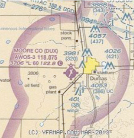
| From city: | 2 miles W of DUMAS, TX |
| Time zone: | UTC -6 (UTC -5 during Daylight Saving Time) |
| Zip code: | 79029 |
| Airport Operations | |
|---|---|
| Airport use: | Open to the public |
| Activation date: | 08/1955 |
| Control tower: | No |
| ARTCC: | ALBUQUERQUE CENTER |
| FSS: | FORT WORTH FLIGHT SERVICE STATION [817-541-3474] |
| NOTAMs facility: | DUX (NOTAM-D service available) |
| Attendance: | MON-FRI 0800-1700 FOR SVCS AFT HRS CALL 806-935-6995 OR 806-676-6412. |
| Pattern altitude: | 4706.4 ft. MSL |
| Wind indicator: | lighted |
| Lights: | MIRL RY 01/19 PRESET LOW INTST; TO INCR INTST ACTVT - CTAF. white-green (lighted land airport) |
| Beacon: | Operates sunset to sunrise. |
| Airport Communications | |
|---|---|
| CTAF/UNICOM: | 122.8 |
| WX AWOS-3: | 118.075 (806-934-3390) APCH/DEP SERVICE PROVIDED BY ALBUQUERQUE ARTCC ON FREQS 127.85/285.475 (AMARILLO NR 1 RCAG). |
| Nearby radio navigation aids VOR radial/distance | |
|---|---|
| DHTr107/29.4 | DALHART VORTAC 112.00 12E |
| BGDr265/30.9 | BORGER VORTAC 108.60 11E |
| Airport Services | |
|---|---|
| Parking: | 100LL JET-A SELF-SERVE FUEL AVBL 24 HRS WITH MAJOR CREDIT CARD. |
| Airframe service: | MAJOR |
| Powerplant service: | MAJOR |
| Bottled oxygen: | NONE |
| Bulk oxygen: | NONE |
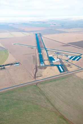
| Runway Information Runway 1/19 | ||
|---|---|---|
| Dimensions: | 6001 x 100 ft. / 1829 x 30 m | |
| Surface: | Asphalt, in good condition | |
| Weight bearing capacity: | Single wheel:30.0 Double wheel:45.0 | |
| Runway edge lights: | medium intensity RUNWAY 1 | RUNWAY 19 |
| Latitude: | 35-50.927335N | 35-51.836928N |
| Longitude: | 102-01.057398W | 102-00.579867W |
| Elevation: | 3706.4 ft. | 3698.1 ft. |
| Gradient: | 0.1% | 0.1% |
| Traffic pattern: | Left | Left |
| Runway heading: | 014 magnetic, 023 true | 194 magnetic, 203 true |
| Markings: | nonprecision, in good condition | nonprecision, in good condition |
| Visual slope indicator: | 4-light PAPI on left (3.00 degrees glide path) | 4-light PAPI on right (3.00 degrees glide path) |
| Touchdown point: | yes, no lights | yes, no lights |
| Markings: | nonprecision, in good condition | nonprecision, in good condition |
| Visual slope indicator: | 4-light PAPI on right (3.00 degrees glide path) | 4-light PAPI on right (3.00 degrees glide path) 15 ft. road, 500 ft. from runway, 295 ft. right of centerline, |
| Obstructions: | none | 20:1 slope to clear |
| Airport Ownership and Management | |
|---|---|
| Owner: | MOORE COUNTY 715 DUMAS AVE. RM 202 DUMAS, TX 79029 Phone 806-935-5588 |
| Manager: | BRANDON COX 5932 US 87 DUMAS, TX 79029 Phone 806-935-6995 |
Comments About Moore County Regional Airport
22-Feb-2013
I must agree with all of the previous comments. Great airport and Super service. Landed here after turning around trying to avoid a winter snow squall. Brandon was enormously helpful. Put my RV9A in the hangar for the night and gave me the courtesy car. Had a good dinner at the 287 Roadhouse, which BTW has a really tasty homemade salsa! Will stop back in here anytime.
18-Jan-2013
One of the best experiences I have had at a municipal airport. Arrived around 3pm. Self serve gas but they came out and helped pump while I called a friend. They provided a hangar for my plane and when I came back to the office, they had the courtesy car waiting and running. Allowed me to take car
for business that afternoon and next morning. Very nice facility as well. Great people.
22-Aug-2012
Landed just before a Texas sized storm rolled in. They let me use an unused hangar for the night and had courtesy car available. Hotels in Dumas are less expensive than Dalhart and of good quality. Nice town.
22-Aug-2012
Stopped in for fuel and overnight, the ramp, fueling facility, FBO building…The entire place, is clean, well kept and should be the model for every small airport in the country. Great fuel price and they have good hotel rates negotiated in the area, also had a crew car, which they let me use overnight.