
Location
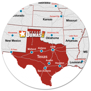 The Dumas region is readily connected to the global marketplace with multi-directional rail and highway infrastructure. The community’s unique geographic location makes it a direct route to productivity and profit. Its strategic central U.S. location is ideal for serving as a transportation and distribution center for to all points.
Located just 45 minutes north of Interstate 40 along U.S. 287 and U.S. 87, major 4-lane highways, Dumas is a large part of The Ports to Plains Corridor project; a multi-state and international effort to expand the transportation systems from Mexico to Canada. By creating a 4-lane highway system that connects to Interstate 25, and continues through the Theodore Roosevelt Expressway into Canada, the corridor is the fastest growing trade corridor in the United States. The intermodal initiative will transform the region into the major trade route from Mexico to Canada and making Dumas a central distribution point. Located just 30 miles north is U.S. 54, another major east-west corridor for the distribution of goods.